Space Engineers

Space Engineers

Not enough ratings
Planetary Air Navigation [New Aircraft Carrier Mode]
   
Award
Favorite
Favorited
Unfavorite
File Size
Posted
Updated
26.957 KB
May 3, 2020 @ 5:13am
Sep 9, 2020 @ 12:01pm
3 Change Notes ( view )

Subscribe to download
Planetary Air Navigation [New Aircraft Carrier Mode]

In 1 collection by fyhring
AirNavigation Collection
6 items
Description
Each of these instruments have their own ground-based transmitter scripts which must be downloaded separately from the collection.


Planetary Air Navigation
Welcome to this script. This is a collection of tools and instruments for air navigation that works in a similar way as in the real world that are used by pilots.
As we now have weather in Space Engineers we thought it would be great to have the ability to navigate in the air even in bad weather.

In this script there are currently three types of instruments:
  • ILS
  • VOR
  • NDB


Systems

ILS - Instrument Landing System
This is a system that allows for a precision landing in bad weather. It contains a localizer for horisontal guidance as well as a glideslope for the vertical guidance.
The ILS doesn't have any options, just connect it to the correct runway and you will be able to land in bad weather.

[New in version 1.3] Aircraft Carrier Mode
This mode enables the ILS to be used on a moving object like an aircraft carrier.
To enable this you must set the
CarrierMode
to
true
in the ILS transmitter CustomData and also enable it in the same way in the aircraft itself.
The normal ILS mode uses GPS points to function, however this is not possible with a moving runway, therefore the CarrierMode requires two additional sensors to be placed. One at each touchdown zone, and must be named
TDZ1
and
TDZ2
. Remember to recompile after setting updating CustomData.


VOR
VOR can be used for both en-route navigation as well as landing, just without vertical guidance.
VOR is a little more complex to use and can be used in many different ways. Take a look on google to find more information about this.

VOR has a OBS/CRS selector, which is the course you want to intercept.
The command to set the OBS to e.g. 180 degrees is:
OBS 180

NDB - Non Directional Beacon
NDB is pretty simple, it shows you the direction of the transmitting station.
With this you can fly what's called QDM and QDR.

Commands
Setting the VOR OBS (through 0 - 360):
OBS 180

Start and stop ILS:
StartILS
StopILS

Start and stop VOR:
StartVOR
StopVOR

Toggle/cycle instruments on a screen:
SurfaceToggle 0 1
First parameter: The cockpit block number (starts at zero).
Second parameter: The screen number within that cockpit (also starts at zero).
9 Comments
Doctor Gray Jan 16, 2021 @ 5:57pm 
I don't suppose you would be down for another feature suggestion, would you? Well, I say suggestion, so feel free to tell me no. I was wondering if it's at all possible to display the systems ontext panels or LCDs not in the cockpit?
fyhring  [author] Sep 9, 2020 @ 12:01pm 
The issue has now been fixed.
Doctor Gray Jul 25, 2020 @ 7:00am 
It's actually Planet 26. I can't code but if there is anything I can do to help I will. 'North' itself is relative to the sun's rotation. Maybe sneak a peak at Whip's compass or HUD scripts, sice I know he has Custom Data settings for the XYZ of the orbit to calculate 'North'.
fyhring  [author] Jul 24, 2020 @ 2:30pm 
Have you spawned the planet or is it the default one?
Im currently having similar issues myself on the Planet26 somehow, and I think it may have something with how the script locates North.
Doctor Gray Jul 24, 2020 @ 7:06am 
I'll post a screenshot if that's alright to show you what I mean. I have figured out why the angles were off in my previous post. It turns out if you have a remote control on a subgrid, the angle of the ILS and VOR will be off by however far that remote control is angled. For example, I have an angled flight deck, offset by 26.57 degrees with a remote at the end to tell the bridge crew what angle pilots need to approach.

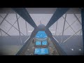
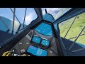
I managed to fix that issue by removing the remote controls, but the localizer is still off on the ILS. In the picture, the runway GPS is just bow and stern, head on. Top left display is ILS, top right is VOR, just like your demonstration world. Runway heading is 133. What might I be doing wrong?

https://steamcommunity.com/sharedfiles/filedetails/?id=2176236469
fyhring  [author] Jul 18, 2020 @ 9:09am 
Thanks for your comment, I think you can place the cockpit tag on the LCDs and it should work. If not please let me know :)
Draken35 Jul 16, 2020 @ 8:26am 
Very nice! But, :) anyway to make it work with custom made cockpits using lcds and text panels?
fyhring  [author] Jun 3, 2020 @ 11:01am 
Thank you for your nice comment means a lot to us!
We do have some issues with the localizer scalloping or "jumping" a bit from side to side. I'm looking into the issue but its a slow process.
That being said I don't believe you'd need to be offset and a far distance away from the threshold.
Perhaps there's an issue with your GPS points to calculate the runway heading.
Doctor Gray Jun 1, 2020 @ 2:49am 
I hate to be the first one to ask this sort of thing considering how amazing this script is and how love I've been at this game, but is there something I am doing wrong with the ILS? When I use it, the glideslope works properly but the localizer is wildly off, where I have to be offset to the runway by 90 degrees and several kilometers away before it lines up. Am I using this wrong or did Keen break something?