
Instalar Steam
iniciar sesión
|
idioma
简体中文 (Chino simplificado)
繁體中文 (Chino tradicional)
日本語 (Japonés)
한국어 (Coreano)
ไทย (Tailandés)
български (Búlgaro)
Čeština (Checo)
Dansk (Danés)
Deutsch (Alemán)
English (Inglés)
Español - España
Ελληνικά (Griego)
Français (Francés)
Italiano
Bahasa Indonesia (indonesio)
Magyar (Húngaro)
Nederlands (Holandés)
Norsk (Noruego)
Polski (Polaco)
Português (Portugués de Portugal)
Português - Brasil (Portugués - Brasil)
Română (Rumano)
Русский (Ruso)
Suomi (Finés)
Svenska (Sueco)
Türkçe (Turco)
Tiếng Việt (Vietnamita)
Українська (Ucraniano)
Informar de un error de traducción


 En Youtube


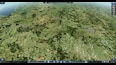
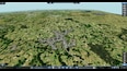
1. How do yo get your heightmaps so accurate?
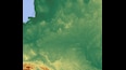
2. How do you get the satellite overlay onto the terrain?
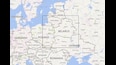
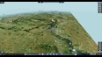
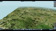
This map (and my other maps) has a true satellite image textures.