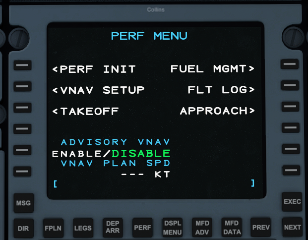
Microsoft Flight Simulator

Microsoft Flight Simulator

510 ratings
The "quick" guide to enjoying FS2020
By ustaritz
I wrote a guide a long while ago like this one for FSX. And it got good reception from people who might be you, who didn't know anything about flying, or using the sim, but wanted to LARP as pilots. Don't we all ?
This guide will teach you the basic concepts of how flying works, what's good practice in a sim ( not always the same in real life ), and how to enjoy FS2020.
There are several ways to enjoy the sim, depends on what is your idea of flying. This hopefully will shine some light.

ps. If you're that Dovetail Games community manager who contacted me about publishing my FSX guide, sorry for ghosting you, it's a bit late i know.
6
68
4
11
5
8
4
3
   
Award
Favorite
Favorited
Unfavorite
Introduction
What's up with flight simulation ?

Flight sims are a niche that is in a way similar to Train simulator but not quite like racing sims. While racing is competitive and high intensity, flight simming, like train simming or something like Truck Simulator is not competitive. It is also not particularly intense. Though this depends on what you do. There is a lot to do in a flight sim, or not, this depends on you, and what you make of the sim. I recommend greatly if you haven't bought the game, to try it out. Firstly simulators can be hard to run without powerful computers. Framerates are not a top priority like in a FPS, but you might not be comfortable playing the sim on low graphics, or with 30fps, moreover, it can take a lot of storage space, and some decent internet connection. The Xbox Game pass for PC can allow you to try the standard edition for a whole month for about 5$. The refund policy on steam is in my opinion, too short of a time to judge a game like this. A month is more appropriate than 2 hours. Also, because of the way the launcher works, you will be downloading the game after launching it from Steam. I'm sure Valve will grant refunds for that reason even if you go past the 2 hours. But nonetheless, it takes a day or two of playing before you can get a good idea of the thing.

FS2020 obviously allows you to fly anywhere you want, in real time, real places, real distances. There is no scaling down of the world like Truck simulator, or invisible walls. So where do you go ? You're lucky to come at this time, where the entire world is now essentially in the game, and accurately. Newcomers take it for granted because we have things like google maps today. But in sims up until now, true, photographic maps, were a luxury. The standard map that came with FSX or XPlane was made of very low fidelity tiles, that weren't really anything real at all. It did the job but it wasn't particularly nice. You had to pay good money for high quality maps, that replaced small parts of the world, and with enough time and hundreds of dollars, you'd find your hard drive to be entirely full and your wallet empty, for a few airports and high quality maps. To give you an idea, i have almost the entire USA as satellite imagery and street maps for XPlanes 11, It's about 1600 Gigabytes and it's not quite FS2020 levels of detail. But it made a whole difference to me.

Now, we can go anywhere, and expect to see great nature, great cities. Even the ones that are not "photogrametric", are still way above what we've experienced for the past 20 years. Anywhere you go, you can look down and see what it really looks like. There's something special about that to me, and hopefully, to you too.
You can explore nature, land on hills and beaches in mountain ranges, find airstrips or just patches of land clear of trees and put your Cub down, take a picture and a coffee, and go somewhere else. That's what you'd call bush flying, for leisure. Or like "professional" bush pilots, you can take your plane to remote villages of Papua New Guinea or South America, on precarious grass strips to deliver people and things to places that don't have roads to the cities. FS2020 doesn't have a built in system of delivering things like Truck Simulator, but there is an alternative to this. It takes a bit of imagination.
FSEconomy is also a website/client that essentially allows you to make a career for yourself, and it is already compatible with FS2020. It has money and contracts and you can make a goal for yourself and even join airlines.
Or you can ignore that and fly jets just for the sake of it. Large jets are an experience of their own and quite different. It's less hands on, more about planning and patience. Learning the procedural parts of flying with instruments and restrictions. And for many, it's where the enjoyment comes from.
https://steamuserimages-a.akamaihd.net/ugc/1490082585096318771/464E2F3043E73B87AE54C05D49F98200246309F7/?imw=256&&ima=fit&impolicy=Letterbox&imcolor=%23000000&letterbox=falseNikol'skoye, on the volga near the Caspian - Russia
  • 8/20 Added Autopilots - Basic Terminology
  • 8/21 Added G1000 basics
  • 8/21 Added Gamemodes and Multiplayer
  • 8/21 Added VFR, Bush Flying and GA Aircrafts
  • 8/21 Added Autopilot - A320 and A320 Throttle usage.
  • 8/22 Added Autopilot - 787 WIP
  • 8/22 Added Notices
  • 8/24 Update G1000 with NEXRAD use
  • ---- Added FSEconomy Tutorial
  • 6/24/21 Added SimBrief and Flight Plan introduction
  • 6/24 Added CJ4X FMS basics
Notices
This sections is for brief information that you might find useful currently.

General recommendations.

Your Windows OS should be up to date.
SSD or M2 installs can make loading times and map streaming smoother. Unless you are limited by hardware.

Pressing Windows G will enable the Xbox Game overlay. This is useful to see your friends list or take screenshots but is also especially useful as you can enable a performance monitor and pin it on your screen. This small panel can show you CPU, GPU, RAM usage in % and FPS.

Multiplayer can be unreliable at times and inconsistent between clients. Meaning sometimes you might be visible to other but you're not seeing anyone, or two people can't see each other but they both see other traffic. This can be due to two things. Either a quirk with how the game picks who is visible or not when there is very high volume of traffic. Or one of the two players is not actually connected. In both cases, check that you are using ALL PLAYERS and not Live Players or both players must be in Live to see each others. If the glitch keeps happening, press escape and go to another server, let it load traffic for a few seconds and go back to the server you wanted to be in. This usually works to refresh your traffic. If it still doesn't work, it's probably a global issue.

Live Weather is also unreliable. From experience, it looks like you need to reboot the game before a new flight to obtain live weather correctly. If you go back to the menu and fly again live weather will break. If you want to use live weather, restart the game entirely. This is usually a good thing to do anyway but it might take time if you have a slow hard drive or CPU. Switching weather presets will not fix it, but might not break it.

This has been fixed since but can still be an issue on rare occasions and seems dependant on location. Some regions in the world might suffer outtages, or general bad service and therefore would return blank weather settings.


KNOWN ISSUES ( 11/24 ) - Asobo

Official MSFS Zendesk Support [flightsimulator.zendesk.com]


What you need
A lot of people ask "can i play this with a keyboard and mouse". I don't like being that guy who sounds elitist but it's like asking if it's worth it playing a racing sim without a wheel.
Yes it's possible, there isn't a wall that just prevents you from playing without it. Is it enjoyable though ? I don't know. A Logitech 3D Extreme Pro is maybe 50 to 60$ and has all the basic functionalities to fly anything including yaw/rudder control.
If you don't want to buy a joystick, do you have a Xbox gamepad ? That can work fine too. If you don't have any gamepad at all. Just buy one. You'll find plenty of uses for it in the future.
I agree that a joystick, like a wheel, is a luxury, and you should definitely consider it, but if you're unsure about it, a gamepad will suit you just fine and gives you pretty decent control and essential keys given a bit of tuning on the axis sensitivities. It even supports key combinations so you can have extra functions accessible.

What specs do i need ?
It's the question everyone asks and nobody can reliably give you an answer because every system is different, and everyone has different budgets and expectations. Check the official requirements.
Try the game pass if you're not sure.

Resources :
There are a number of websites that can help with different things.
The two that you might use the most are Skyvector and Simbrief.

Skyvector is an online aviation map. It has several uses, it can be used for VFR as it features terrain, some landmarks and roads and points of interest you can use to know where you are if you were to fly around those places without a GPS in real life. Obviously airports are also marked, not every strip is there but most airports are marked, and can be clicked on to bring up important information about them. Such as altitude, runway types, sizes, local weather and "plates" which are individual documents that define procedures around that airport.
It also has more technical maps meant to be used for IFR, with airways, beacons and more abstract stuff that you would care about if you're navigating with your GPS and flight plans etc.
It also doubles as a flight planner. It is capable of giving you routes between locations, with estimate time and distances etc.
For Flight planning, the standard is mostly considered to be Simbrief.

Simbrief allows you to create complete flight plans, and export them. ( not currently supports FS2020 plans but surely will in the future )
Those flight plans also feature fuel usage, procedures, very complete navigation and weather predictions and all the stuff you might need if you are flying between airports.

Fuelplanner is also a thing you might use. If you don't want to set up a complete flight plan, you can get an estimate of fuel usage between two airports with this simple calculator.

Simtoolkit Pro
Sim Toolkit Pro is a free, very well produced app, that features several functions like a live map, weathers and flight plans you have saved and other stuff. It integrates with multiplayer networks, connects to your simulator to track you on the map. It is a bit like your in flight Tablet. You can find uses for it or simply track your progress.

Gamemodes and Multiplayer
Quick explanation on the gamemodes and how multiplayer works.


Bush adventures with BradM and the lads around Chagual airfield, Peru.

Your basic gamemode is obviously freeflight. You go in there to pick a place to go to, set a flight plan etc and this is your entry into multiplayer.
The way MP works is very simple. There is no need to set up a server or a lobby. Everyone on your server region is synced with everyone else. Regardless if you have someone as a friend or not.
If you want to fly with a friend or join a group flight, all you need is to spawn at the same airport, or if you want to join in flight you can click on the map and set it as departure and you will spawn in the air. If you match server with whoever you are looking for they will be there.
This can be slightly unreliable sometimes where players will disappear or some will not see each other. These quirks will hopefully be fixed with time.

The confusion is with the multiplayer settings.
Live Players and All Players are slightly different.
Live players matches all other players using Live as well. When live you are also forced to use Live Weather and Time. This means all Live players fly in the same condition. And Live players cannot see people who are not Live.

All players is simply all players. When set to all you will see everyone and also Live players too but they won't see you. All players also allows you to set custom weather and time. This is the mode you will mostly use when joining groups because everyone can see each other. Except Live players who you can see, but they can only see live players.

Group only is as it says. You need to add and invite people as friends and only them will show.


Currently there seems to be a problem with Live Weather not working. This seems to be intermittent and until it is fixed, restarting the whole game is the only way to obtain live weather if you exit back to the menu at some point. In general, it is advised to reboot the game in between two sessions to refresh weather.
You also might run into the problem of online players not showing. If you are using All Players and people are not there or have disappeared you can try to refresh your server.
Press escape and click on your name on the top right. Try switching to a different server, and then back to the one you want. You can also try to set status to offline and then back to online to refresh it though i don't know if it really does anything. In general it can take a bit of time for other people to load in.
The Basics of Flying
If you are reading this guide you're either a total new pilot, or maybe you've been casually trying it out for awhile, maybe in FSX or XP11 before and you're interested in progressing.
In both cases, i think it is essential to start with the ingame lessons. I've done them myself and they are a perfect introduction to what the core mechanics of flying is manually and it's good to be reminded of some things sometimes.
So do those lessons. Listen closely to what the instructor tells you and try to get them all completed smoothly. At the end you should already understand the basic behind taking off, landing the small Cessna, and things like trim. The final lessons involves leaving one airport, going to a waypoint and landing at another airport. Just with your compass and your instruments. If you can complete that, you're ready to do the same thing basically anywhere you wish. And that is a massive step forward towards getting the full experience out of this game.

"This can't be good for me but i feel great !" - The Postal Dude. ( Except this time, it's good for you )

Here's some of the things that this tutorial covers in a bit more words :

Planes use air to fly, to get air, you need to move, and to use the air, you need wings. When air goes around the wings, you create lift that pushes you off the ground.
The speed of the air around you is the most important thing to understand and it is not quite as simple as cars.
In aviation, the idea of speed is usually referring to "Airspeed", or IAS "indicated air speed". It is called airspeed because it is not defined by how fast you're going in reference to the world, but more like the speed of the air around you, adjusted for air pressure. It is measured with Pitot tubes.
You need to move air to fly, this is what you're paying attention to, too slow and you can't fly, you stall and fall down. Too fast and you might break the plane apart. Most of the time, your airspeed indicator is color coded, green is good, red, yellow is probably not good.
Wind can change that, as demonstrated by Squirrel in a video, a fast enough wind into your face, can actually lift you up in place. A strong wind facing you back, is the opposite of what you want when you're hanging around close to the ground. It means you need more power and ground speed to get up or stay in the air. But up in the air, it also means you got less air to fight through to go fast. All in all, watch your Airspeed, keep it high enough, and not too high. Every plane has different appropriate speeds, and those vary depending on how heavy you are, and what the wind is like.
Another thing about airspeed is, that it is not directly related to your actual ground speed. This is why we fly high up to go fast. Up high, air is thinner. To achieve the same airspeed, you go faster to catch more air, and there is less air to drag you back, so essentially, the higher you are, the faster you go, but your airspeed is mostly the same. And you still risk stalling, or overspeeding the same way you do down below.
It is something that you need to pay attention to as well when you fly into areas with high elevation. Being at the top of Everest is like being a 30.000ft. While most of the world is somewhat close to sea level, there are cities and airports built on top of high ground, or airstrip on the side of mountains, landing and taking off from there takes more power and close attention to performance due to thinner atmosphere.

With that understood, flying around is mostly handling your plane with consistent, measured inputs. Every plane is different, some are more agile than others. The tutorials in game will teach you some things, otherwise it's simply practicing. Get used to your point of view, to reading the environment and the instruments and how that tells you where you're going to be in 30 seconds. Flying is a game of patience, it's not like spaceships in Star Wars. You want to watch further away than your nose, know what you're going to do, and how it's going to happen.


The front instrument panel of a Cessna

Your Attitude is the orientation of your plane depending on the horizon, it is an essential instrument. Point your nose up and you go up, nose in the ground, you go down. Pretty obvious. But it doesn't mean you're always going towards where you are pointing.

If you point the nose up, you lose airspeed, and the more you lose speed the less lift you generate, the less you will climb until your start falling down. You might be pointing up, but you might be losing altitude and not see it.
It's important to watch your vertical speed indicator. This reliably tells you how fast you are climbing, or descending. Most planes will not fly straight with the nose pointing to the horizon, at normal speeds, most planes fly "level" with the nose slightly pointed up. Vertical indicator tells you if you are really flying "level" or not. flying level is flying "straight", not going up or down.
Try keep it at zero when you cruise. Obviously it's a lot of work, with Trim it is much easier. You are not expected to be dead on zero at all times. But the better to keep it stable, the better it is.

Another indication you can watch is called "angle of attack" or AOA. It is the angle of your wings relative to the wind. It is a good indication of your current condition. High angle of attack means you are aggressively pushing your wings against the air, you're probably too slow and pointing up. When cruising level and stable, your AOA is a little over 0.


The AOA indicator in the Icon A5. The bottom half is positive, more positive is more aggressive angle. Upper half is negative. You're rarely there unless you are push the nose down.
The Basics of Flying II
Trim is like putting an offset on your steering wheel. Most of the time you only use Elevator trim. The elevator is the back wing that controls how your point your nose up and down. As you go faster, that wing will create more or less lift. The key to flying straight and level without autopilot, is to maintain speed, be level, and then trim.

If you let go of your joystick your plane will often dip down, or up. You need to set an offset to the elevator so that it compensates that effect, without you having to touch the joystick.
Start by trying to maintain the same altitude, watch your vertical indicator and keep it at zero. At the same time, push or pull the throttle so your speed stays the same. If you have to push or pull on your joystick to stay level, you need to trim up or down accordingly. Start trimming and watch the reaction of the craft, slowly take your stick to the center position as you trim and with some practice, you will be able to do this quickly and with the correct trim and throttle, you can fly almost perfectly level and straight without touching anything.
This is especially important if you want to enjoy flying the General Aviation aircrafts that sometimes do not have any autopilot functions. Proper trimming allows you briefly let go of your controls and check your maps, GPS, ATC or just look around for a minute.

Flaps are basically wing extensions that extend and retract. Their basic function is to create lift. They effectively allow you to fly slower, but they also slow you down, that's why you need to be able to extend and retract them. When using them, you should know how your plane will react to it, and also at what airspeed is it appropriate to use them. Most planes have "Take off flaps" or simply small angle flaps that allow you to get some lift when departing, but not so much drag that it takes more speed and runway to actually lift off. When landing, you usually have landing or full flaps settings, you want maximum lift, slowest speed safely possible, to land slow and gentle and in the correct spot. Depending on where you are going and what you fly it might not always be required to go full, or half or whatever. That comes with practice and knowing your craft. There is always plenty of videos and documentation in the real world that can teach you those things about planes in the sim. Some have a plate on the dashboard with the reference speeds and limits for each flap angle and also when your landing gear should be retracted.

The flaps lever in the Cirrus SR22. Note that the airspeed limitation for each flap setting is also specified. ( KIAS )
VFR, Bush Flying and GA Aircrafts.
VFR stands for Visual Flight Rules. In VFR you are not always tracked by Traffic Control, and unlike IFR, it is not always a requirement. This depends mostly on where you are and the rules that apply in a particular airspace. You don't need to worry about this stuff in the sim really. Unless you are headed to a network like VATSIM or PilotEdge which require you to have a at least basic understanding of real life regulations that apply to VFR or IFR. If you want to learn about it, you should look for real manuals and lessons intended for real life flying. VATSIM has an extensive learning center on their website that can serve as substitute for real manuals that you can use for sim flying. But there are other sources of course.

Some of the basic principles of VFR is that as is says on the tin, you should be able to use visual references for getting around, this means night time flying, and bad weather are prohibited. Airspaces are also divided in classes. Most notably, class A is strictly no VFR, and down to class F and G which hare essentially uncontrolled areas.
All these different rules make for a lot of things to know and again this is not a requirement for learning the basics of flying and even multiplayer. This only matters on realistic networks like vatsim according to their standard.

Bush Flying is essentially codeword for flying in areas that are probably not controlled, have little traffic and infrastructure. The Bush Flights game mode in FS2020 offers a nice VFR experience. It puts you into a small GA Aircraft and gives you a Nav Log with descriptions and instructions on where to go to reach the next airport.
Note that the Bush Flight activity is separated in legs of various lengths that you can do one after the other at your pace. The Nav Log is fairly straight forward. Each step is described visually in text and also has a suggested heading and time. Ideally, you are headed in that specified direction for the specified time and when the clock hits that time you can switch heading to the next POI ( Point of Interest ). That's why it has a chronograph you can start, pause and reset.


It is obviously hard to be precisely on the clock if you happen to use a different cruise altitude or take a detour somewhere. It is a good idea of how long you should travel in a certain direction but paying attention to your surrounding and what is described is most important. This is similar to driving in the Dakar rally. If you are not on a precise designated track or road, your distance traveled might differ from the book and you should pay attention to the landmarks at all times and use them as reference.

If you're having trouble completing those missions, there is as of now (8/21) a way to "cheat" in it. It kind of ruins the challenge and i'm actually hoping they fix it before i try the other challenges. At least for the Rijeka - Santorini campaign -
I have notice that the INSET minimap on the G1000 actually has the entire flight plan on it, you cannot use nav to follow it as it is not activated but you can follow it manually
This does not apply to the non-electronic instruments for this reason.

Note that i don't believe it is required to physically travel through each point of interest to validate the missions. Though the Garmin seems to recognize the POIs as waypoints since it says POI on the navigation helper on the top. You should be able to validate a mission just by going to the next airport which is specified at the end of the log.
The VFR map does not have a blip of your own plane so even if you do decide to skip everything and get to the airport, you still need to get your bearings correct to find it if you are in a plane that doesn't have GPS.

To validate a trip, you must fully stop for a second or two until the screen pops up. I have once stopped on a taxiway and it worked but on a different strip i parked on the side of the runway and it didn't validate until i moved closer to the runway. So i would suggest you just stop on the runway and save you the trouble. It doesn't matter anyway.


Most GA aircrafts are propeller planes as far as basic Microsoft planes go.
As for all of those planes, startup procedures are all on the integrated Checklists which you can complete yourself or automatically so you shouldn't have problems starting up. ( Cold & Dark start is only available when spawning at a parking spot, if you spawn on a runway or in the air you will spawn with all systems and engine running )

Some things particular to planes with propeller engines that can be important and are not an issue with the airliners and jets is engine monitoring. Unlike jet engines, props use engines that are more similar to cars. These engines mix air and fuel at a specific ratio to be injected into the pistons.
Like cars, altitude means different air density, and cars also struggle at high altitude as they get starved of air, this cause cooling issues and reduces power. Most engines are designed to be optimal at somewhat close to sea level. High altitude driving and flying requires to adapt the fuel intake so the air/fuel mixture ratio is ideal.

Now i do not know what specific mixture is appropriate for each altitude as this is varying between aircrafts. But the general rule is that mixture is reduced, or lean, the more you fly up, and rich, the closer you are to the sea. This varies with engines, but you can use the auto-mixture assist in the game settings which should adapt mixture automatically. The mixture setting is usually the red stick, next to the throttle or somewhere else. This does not apply to Turboprops, because air injection is increased.

The other concept to look for RPM.
No every prop plane is like this, but generally if your plane has a RPM lever ( usually a blue stick next to the throttle ) that plane has a "constant speed propeller" engine.
Similarly to helicopters, the propeller is designed to be spinning at the same RPM constantly. By using the throttle, you do not increase RPM but instead increase pitch of the blade. Increasing the pitch of the blade gives it a more aggressive angle of attack on the air, and it will then push more air. As said earlier, angle of attack is how much air you are pushing under your wing, or spinning blade in this case. The blades on a constant speed propeller engine are mounted on a rotating axle which changes the pitch of the blade as you use the throttle.
I am not an expert on this but i think the general rule is that when taking off, landing and maneuvering around you should be on max RPM set and use the throttle, but when at cruise altitude, you should be setting the RPM to a lower setting to optimize fuel efficiency and reduce engine stress. Again each plane is different, and each engine is optimized for different RPMs at different cruise speeds and different mixtures at different altitudes. For the most part as a learning sim pilot, you don't need to worry about engine maintenance and fuel efficiency.

This is stuff you can look up on the internet and try for yourself, i can't certify those values are realistic and applicable in FS20.

IFR and Flight Planning with Simbrief.
IFR stands for Instrument Flight Rules. To put it simply, any flying done in any weather considered worse than VMC standard, must be done IFR. An IFR aircraft ( and certified pilot ) can use instruments to fly through weather, at night, use radio, GPS beacons and whatnot to navigate safely. It is also required to fly in class A airspace which is mostly everywhere above 18000ft ASL.
Most if not all commercial flying around the world is done IFR, and a requirement for this is to pre-plan your flight in advance, among many other things which i won't get into. As far as the sim goes, you can always do whatever you want it's a game. But if you want to experience jets and airliners using a flight plan is essential as they are designed to be used strictly IFR and work best that way.

FS20 can generate a basic plan visually on the world map and works decently well, it will also input your plan into the Flight Computer automatically.
Or you can use the SimBrief website to generate a more complete plan, which you can print or read as a pdf and can even come in authentic airline formats if you wish. SimBrief comes especially useful with the FBW 320NX mod or the CJ4X, or Aerosoft CRJ as they come with more complete Flight Computers that can use more of the data given to you by the flight plan.

This section of the guide will try to teach you how to read the essential parts of a flight plan.

Firstly, you should go to Simbrief[www.simbrief.com] and set up an account, link it to navigraph if you happen to have a subscription, if not you will be using outdated navigation data but in most cases it will not be an issue. Once that is done, use the Dispatch tab to go to the editor and create a new flight.


There are many options to choose from when creating a plan but most of it you don't have to touch and can be left to automatic. You mostly only need to pick your departure and arrival airports, which aircraft you use. Pick the correct weight unit you want, and the OFP Layout is what format you want to use. I have always used LIDO as it is default on SimBrief and imo is fairly simple.

Regarding the Airframe, there are many to choose from but in many cases using a custom airframe for planes in FS20 can be better as far as fuel consumption and weight limits are concerned. If you are using the FBW 320, the WT CJ4X, HD 787 or the CRJ, each should provide on their respective website a link that will allow you to quickly copy their custom settings so you can pick that specific plane in the future easily from the drop down menu. For example if you click on the simbrief profile link from the FBW 320 github, you will be taken to the fleet page where all the numbers are already filled in for you. Just press Save and the custom 320 will be ready to use and the fuel and weights and performance figures should be more accurate.

Additionally, you should write your Pilot ID somewhere. This is a simple ID number that some planes in FS20 or other sims can use to sync up flight plan automatically and autofill the FMS for you making it quicker. The FBW320, CJ4X, HD787 and CRJ should be able to use it once you set your pilot ID in their respective FMS option panels.


Below is the routing, you can pick different options on the right but most of the time the default one is fine. In some cases there might be funny things happening especially if the sim and simbrief do not match AIRAC cycles, if you see something odd on the map below you can always try the alternates. If something seems off in the sim when looking through the map, you can always switch SIDs and STARS around for something that looks more appropriate.

Press Generate OFP on the top of the page to create your pdf.
You can get some information from the next page or just go straight to Print/View PDF button to get your plan in full in your browser.

Next Section >


SimBrief 2
We have our flight plan in PDF, in this example LIRN ( Napoli IT ) to EDDM ( Munich DE ) in the Citation CJ4X WT.
The left toolbar has the plan ordered in pages for quick access.

Page 1 : Summary and Fuel


This is the first page. Depending on which plane you are using some of the highlighted elements might be required or not by the flight computer. These are some of the elements you might need.

CRZ SYS if your cruise index, required for Airbus and Boeings, in the CJ4, it is a custom mach profile called MCR and is not needed. If you use the FBW 320 it should be set to 8. It's basically your economy rating.

AVG WIND is the average winds you will be seeing in cruise (Heading/knots)
AVG ISA is how warmer or colder the air is compared to the average for the area during cruise. This is autofilled on the 320 and you shouldn't need it at all in FS20 afaik. But if you venture into other sims in the future those might come in handy. ( The 737 Zibo for XP11 is an example ).

Below are your Estimated and Maximum allowed weights on Take Off ( TOW ), Landing ( LAW ) and the Zero Fuel Weight ( ZFW ).
( Zero Fuel Weight is the mass of the plane with it's passenger/cargo load but without the fuel. )

Below is your suggested cruise altitude. In this case FL430 which is 43000ft. You are not required to use it specifically.

The Planned Fuel area is obviously important.
Block Fuel at the bottom is the total amount of fuel. Its the number you are looking for when setting your weights in the sim panel. In this case it reads 3001 and the plan is set in Pounds (lb) units so you should set your weight in the sim to 3000 pounds of fuel roughly.
To be more specific, TRIP is estimated fuel from TO to Landing. CONT is contingency, ALTN is fuel to fly to the alternate airport if the original destination is unavailable. FINRES is extra reserve usually worth 30 minutes of your time.
Some systems will require you to fill in specific fields with the correct weights, sometimes not and it will be autofilled.


2 : Routing and Impact


This is the routing page. It is fairly easy to decode.
LIRN/06 is the departure airport and runway
MOLUX5A is a departure SID. SIDS and STARS and usually recognizable because they have number. Waypoints do not have numbers.
MOLUX5A MOLUX is the MOLUX5 departure and MOLUX waypoint at the end.
DCT is not a waypoint, it means DIRECT as opposed to using an airway. Between every waypoint will be a DCT except if it's included in a SID/STAR like MOLUX.
TORPO GEMKA RASTA REDBU are all waypoints and you are to go direct to each of them in sequence, this is the default way to do it and it's pretty simple.
Q112 is an airway, airways are recognizable as they usually follow this format of a single letter followed by a number. In a FMS, an airway must be accompanied by it's end point. In this case, we exit the Q112 airway at the NAPSA waypoint.
NAPSA NAPSA3A is the arrival STAR
EDDM/26R is the destination airport and runway.

So this reads as follows, Depart LIRN from runway 06, using the MOLUX5A departure to MOLUX, Direct TORPO GEMKA RASTA REDBU. Use Airway Q112 up to NAPSA and follow the NAPSA3A STAR to land on 26R at EDDM.
The actual landing procedure is up to you to pick, ( as in ILS, VOR RNAV or visual etc. ILS is usually best )

3 : Times and Weights


This is your weights, again some planes might need thos values or have them autofilled. This is pretty simple. Your pax number, Your payload is total weight of passengers and cargo ( here it says 1020lb but for bigger planes it will often be written in a fraction of the total, something like 31.6 actually stands for 31,600 lb/kg
You can see your estimate ZFW, TOW LAW and Block fuel again here.

4 : Airport WX List


This is where you will be able to read the weather information and other notices. Most importantly for the sim you will need the departure and arrival METARs. These can be confusing to decode but are fairly simple. Most of the time for your performance programming for TO and Landing you are interested in the winds, temperatures, QNH.
Looking at LIRN we have :
17004KT : KT stands for knots which indicates this is our winds. 17004 means 170° and 04 knots. In some cases VRB ( variable ) or G ( Gusts ) might be added but you cannot input that into the perf page.
( In most cases, gusts mean that you might have sudden airspeed loss of gain during your take off roll and the idea is to give yourself a little more time before rotation to compensate )

32/18 is our temperature at LIRN, you should input 32 in the Temp field ( in Degrees C )
Q1017 is the atmospheric pressure, depending on where you are this will either be in bars or inches. You can always use the knob to do a quick conversion by setting the baro where you want and then switch to the other unit to get it converted in the correct unit. In this case, our QNH is 1017

How to use this data in a Flight Management Computer can vary from system to system and i will be covering them in another section.


Autopilots - Basic Terminology
Before getting into specific systems. It is important to break down the terminology of Autopilots. Knowing these terms will allow you to understand how to use the A/P in most of FS20's aircrafts, as most are based on the Garmin and it's different layouts.


The autopilot board of the TBM

This is a good example of a Garmin based Autopilot and the terminology mostly stays the same. The difference might be that these buttons and knobs could be in a different place depending on the plane. In the case of the TBM, it has this panel. Something like the Cessna 172 G1000 has those functions on a column inbetween the two screens, and the knobs are on the sides of the screens.
  • AP - This is the main Autopilot toggle ON/OFF

  • YD - Yaw Damper. It is a automated system that tries to correct oscillations by measuring yaw variations and dynamically counters it to maintain a comfortable cruise. This is often required to activate certain functions of the autopilot, or the autopilot altogether. It should mostly be On.

  • XFR - XFR stands for Transfer. This is a switch that allows the user to pick whether the autopilot uses the pilot, or co-pilot side instruments. I don't know if this is simulated in the planes by Microsoft as i think both sides are synchronized so this doesn't need to be used. By default it should be set to the left hand side ( the pilot ). If you were to fly from the right seat, you would transfer control to the right hand side.

  • FD - Flight Director is the purple/green arrow/cross on the attitude indicator of your electronic instruments. This shows what the autopilot is trying to do, and what you should be doing if you wanted to fly exactly like the autopilot would. For instance when taking off and flying by hand out of an airport with an airbus. You should be trying to follow the marker on the screen, by doing that, you would be following the correct heading and climb/descent that is set in your flight plan and flight computer. It is okay to deviate from it if you want to.


    The horizontal bar shows desired inclination. The vertical shows desired roll.

  • ALT - This is the altitude hold. When it is On, the A/P will level off at that altitude when it is reached. there are several ways to get to that altitude and this function is combined with either one of them.

  • ALT SEL - The ALT SEL knob can be turned to set the desired altitude. It can be clicked to instantly set the desired altitude to your current altitude. Clicking the ALT SEL knob and the ALT button together will make the plane level off instantly ( if AP is on ). If you are already leveled off, turning this knob will not make the plane move. You need to combine it with VS or FLC to go from one altitude to another. It is good to prepare your next altitude change in advance.

  • VS - VS is Vertical Speed. This will make the plane climb or descend at the desired rate in feet per minute. If you are 3000ft and want to get to 6000ft. You can set 6000 with ALT SEL, Press VS, and then use the Nose Up or Nose Down buttons/wheel to increase or decrease your rate of ascent/descent. 1000ft/m UP will make you reach 6000ft in 3 minutes. You MUST watch your speed as you do this and set the throttle so you do not stall or overspeed.

  • FLC FLC is Flight Level change is also a way to reach a desired altitude set with ALT SEL except the rate is variable. Instead of setting a rate of feet per minute, pressing FLC will set a speed. The plane will then try to climb or descend will maintaining that speed. You can change the desired speed with the down and up buttons/wheel. This is mostly safer than VS as your speed will be consistent and you can maintain your throttle and the plane will do the work.
    When climbing, you should increase throttle, or decrease desired speed so the plane can climb steeper. If you are descending, you must reduce throttle first to trigger descent. and increase desired speed to descend steeper.
    Similar to VS, FLC will be disabled when you reach +/- 500ft from your selected ALT and the plane will level off slowly.

  • VNV - VNAV is vertical navigation. This is used when you have a flight plan set in the flight computer, with the performance numbers correctly defined. This setting will follow the altitude and speed limitations/requirements set in advance. Whether this works in the basic planes or not is not something i'm certain of. Sometimes the numbers can be off but if you have all numbers set you can try. Theoretically, the plane should be able to follow that vertical path entirely by itself. The only requirement is to set cruise altitude when taking off, and bottom altitude before your TOD ( top of descent ). More on that later.

  • DN/UP Wheel This wheel or Nose Up and Nose Down buttons define your rate of vertical speed when using VS, or your desired speed when using FLC

  • HDG - Heading Hold is the most simple way to go somewhere. HDG will make the plane follow a compass heading that you set with the HDG knob. You can also click the knob to set the desired heading to your current heading.

  • NAV - NAV is a more advanced heading function. It can follow your flight plan or when you use the Direct-To function for example ( the line on your map )
    Secondly, it can also follow a beacon. If you wanted to navigate using VOR, you would tune your radios to the desired VOR, and the NAV would head towards it.
    It is required to set your bearing mode to the correct one. This can be found in different locations depending on the plane. The Bearing mode should be on VOR1 or VOR2 for your tuned VOR radios, or to FMS/GPS/NAV to follow the map plan. Note that a white line is not Active. NAV will follow the purple line as purple means active leg. If you missed a waypoint or a bug cause it not to be activated, NAV will try to go back to activate that leg. In the flight plane menu you can activate a leg manually if you want to skip a part and be back on track.
    More on that later on how to use the flight computers which work in conjunction with NAV/VNAV.

  • APR - APR / LOC / LS is like NAV but intended to be used for final approaches like ILSs. An approach has to be set and the leg active. Once the approach is active in the plan pressing approach would make the plane follow the Glideslope. The Glideslope is the trajectory descending down to the runway, it gives you a lateral and vertical indication of how accurate you are on the landing and you should follow it when using it. This is not always working in small planes and it will not land by itself. I personally fly by hand on final most of the time because it is more reliable and fun.

  • BANK - BANK is a switch or a knob that can set a maximum roll limit. Typically in cruise you would click bank to set Half Bank. This limits how much roll the plane can do so you don't shake your passengers too much. It should be off outside of cruise so you are as agile as possible.

  • BC - As far as i understand Back Course is a used to align yourself on the opposite side of a runway that has a LOC/ILS system.
    If for instance an airport only has an ILS for one side of the runway, BC would allow you to use that runway on the opposite side and align yourself using the guidance approach system. Even though that side of the runway does not actually have one of those systems. I don't know if it works or not here.
Autopilots - Garmin G1000
There's a few things to know about the G1000 related to the previous part.

In order for the autopilot to properly follow the purple line on the GPS which you set using a flight plan, or Dir-To. You need to set the CDI to FMS.
The CDI like a compass which points to VORs and beacons and your flight plan accordingly. You need the CDI to be set to FMS/GPS mode for the Autopilot to use that as it's NAV heading.


At the bottom of Garmin are keys to activate some functions.

For the NAV to work, click CDI until the compass is showing FMS. then the autopilot should follow the purple line on the map.

There are other functions here we can use :
  • INSET : Inset is the small map on the bottom left of the panel. You can zom and unzoom that minimap with the range knob on the right. Click Inset and you can then activate Nexrad which is the weather radar, or Top which is the contour lines for terrain.

  • PFD : PFD opens several options, WIND brings up three different ways of displaying wind direction. Very useful to know the wind around you. It can show wind direction and it's speed. BRG1 and BRG2 are bearing indicators, they can also be set to beacons or FMS etc. This is not available when using Arc CDI. HSIFRMT ( HSI Format ) changes from Arc, to Full Compass CDI. This is just preference. In this case it is set to Arc.
Direct To

Direct to is a quick way to head to any airport straight on. Ideal for VFR.


The DirTo button is the one with the arrow, on the bottom right corner of the Garmin.
Clicking that button will bring up a window on the bottom right of the screen where you can input a ICAO code for an airport or waypoint.
Using the slection knob can be annoying on the fly because of the camera shake, it's good to zoom in close or use active pause to operate it. It takes some getting used to, the larger knob is usually for moving around the window, and the smaller knob is for flipping through letters and numbers.
Clicking the knob enters/exits the window.
After pressing DirTo, if the window isn't flashing, click the knob, and use the bottom and top knobs to input each letter and number of the code, note that as you input letters, it will filter out letters that are not available for the next one making it a bit quicker. ( If you have [] and [] doesn't exist in the database, the computer will skip to the next letter ) For that you should select letters in order to avoid confusion.

One the icao is correct you should check the name of the airport if it's correct. If it is, you can press enter and the Load? button should be highlighted, and you can press enter again. The Garmin should now have a direct line to that aiport.

Additonally, you can press the NRST button on the bottom of the screen, use the knob to scroll through the list of nearest airports. From there, with an airport highlighted, you can press the DirTo button and it will auto-fill the selected airport into the DirTo menu, you then only have to press enter to load/activate it. This is obviously faster and a nice way to go from airport to airport casually and practice your landings and cruise without having to plan anything.
It should be noted that DirTo does not take into account any vertical navigation, so in mountainous terrain, you might have to deviate and figure out a way around to arrive to your objective.


The FPL button brings up the flight plan menu. If you have set a flight plan in the menu, it will be there. As said earlier, if you end up with your GPS showing a white line, it might mean you have skipped a previous waypoint. In this case, you can go to the FPL menu and scroll towards the waypoint you are currently trying to go to, pressing Enter on that waypoint should activate it as your current leg and turn the light purple. Then you can use NAV again to follow it.
If your flight plan is empty, you can add waypoints and airports manually in sequence.

The PROC button is procedures. This is used to select your departure and arrival procedures, runways. This is auto-filled by the game if you set a plan before the flight but i haven't seen it work when going from an empty page. But that might be me.


Using NEXRAD

NEXRAD is a weather service that allows pilots to get precipiation and cloud coverage on their Garmin map. It is either downloaded to you or if your aircraft is equipped with a NEXRAD radar, you can have live detection. This is very useful when you are flying in weather, especially live weather, with more complex structures ).
the radar will show cloud and precipitation formations in front of you or on the map. If you were strictly VFR or wanting to avoid bad weather in general you would be using this to avoid the major cells if possible. You an get horizontal reading to direct you around them, and a vertical reading where you can see the height of cells and see if you can fly over them.

First Press the MAP key on the right side display to access map options.


This brings up several options


GPS will bring you to the menu where you can enable TOPO or NEXRAD.
TOPO is isoline lines like the ones you can have on the VFR. It is essentially a more detailed terrain map, useful to navigate in IFR around mountains.
NEXRAD will enable the radar detection.

This will enable the display of weather on the map. This is less detailed and in reality, would be delayed by several minutes because of how long it takes for Nexrad to detect, process, and send the data to users. In the sim the delay is probably not modeled.

The DISPLAY button is where you switch between the map, or the live radar display if your plane is equipped ( they have a tube thing sticking out the wing, like the TBM or the Caravan ).
When clicking DISPLAY you switch to Weather radar, and then can click on WEATHER and, you now have HORIZONTAL and VERTICAL options.


This is the Horizontal mode. You see a field in front of you and can change heading to go around things. It updates every couple seconds.


This vertical mode. You can see if you should go up or under or stay where you are to avoid a cloud. note that the vertical range is over 60.000ft. What might look like something you can avoid, you need to pay attention to that as it might be impossible to reach, and the ground is also not at the bottom of the radar. To see if you are clear or not, use the dots. The ones in the middle is where you will be if you stay level.

In both cases, using the Range knob on the right of the Garmin will extend or shrink the detection range for more accuracy.


Autopilots - A320
While most autopilots are mostly similar in terminology and concept, the airbus philosophy is slightly different. Mainly if you compare it to the equivalent Boeings. Most Boeings use the same general workflow and most Airbuses also follow their own workflow. Though i think it's fair to say that Boeings A/P are somewhat closer to what you get on a Garmin system.

We'll cover the Airbus first here as it is quite popular and can be a little confusing because of it's differences.


The core premise to understand with the Airbus A/P is the difference between Selected and Managed.
Airbuses are designed with more automation in mind. And Managed mode is essentially about letting your flight computer take over control. While selected, is putting the user in charge of selecting the desired values in real time.
Managed mode works according to the flight plan specified in the flight computer. If you set a flight plan in the game menu, managed mode will use the values from the flight computer to navigate. I'll explain flight computers in another chapter.
Each knob is turned to select the desired value, but it can also be pushed or pulled. This is done by putting you mouse over and clicking on the knob when the arrow pointing up or down shows up. On is engaged selected, and the other is engage managed mode. The way to remember is that when pushing, your are giving control to the airplane ( managed ). If you are pulling, you are taking control for yourself ( selected ).
  • Speed : When pushed, the autopilot will automatically follow limitations specified on the flight plan and the standard operating speeds of the airplane. This means that it will seamlessly switch from the different speeds allowed depending on your flaps setting. When landing, it will gradually lower the speed limit as you extend flaps, until you are in landing flaps configuration at which point it will be set to the final airspeed intended for proper touchdown ( Vref ), depending on weight and winds. It should also automatically switch speeds depending limits. Globally it is always forbidden to go over 250kts under 10.000ft. When you are below 10 thousand, the A/P will set desired speed to 250kts or under, and switch up to cruise/climb speeds once over. this can mean the plane will sometimes level off around 11000 when descending to help reduced speed before heading down below 10k.
    When using Selected, the desired speed can be set by turning the knob and the value will show up on the top bar and will be used regardless of speed limits, flaps level and situation. This is meant to be used to control speed manually if your flight plan is not set correctly, if you want to cruise faster you can enable it temporarily, or you can it to a desired speed if the ATC asks for it. When using Managed, the speed value is replaced by a dot. There is more to this at the end of this section regarding throttle control.

  • Heading The next knob above the LOC button is the heading knob. Similarly, it is pushed or pulled to use managed/selected mode.
    Selected mode is like your heading mode in the Garmin. It is used to follow a specified heading. Managed mode is similar to your NAV function. It will turn into a dot on the to panel and the A/P will follow the planned trajectory on the flight computer / map display.
    the LOC button is used when intercepting a landing procedure on final.

  • The center of the console has three buttons. AP1 and AP2 are the main toggles for the Autopilot.
    You only need one of two active as both pilot seats and flight computers are the same.

  • A/THR is the toggle for automatic throttle. This is required for the autopilot to be able to control airspeed.

  • Altitude : Selected is like altitude hold, it used in combination with the next knob which is your vertical speed knob. When pushing this and turning on managed mode, the A/P will follow the altitude constraints specified in the flight plan. The A/P will NOT climb or descend to your cruise/landing altitude if you do not specify it on the top bar with the knob. Even if it's set in the flight computer.
    When taking off, you should have your cruise altitude, or at least you initial climb altitude set, then click managed. Each time you push the knob ( engage managed ), you trigger a climb phase, or a descent phase. If for instance you want to cruise at 35000. When taking off you should have 35000 set. After take off, once you are ready and you activate AP1, the plane will climb up to 35000, if there are altitude limits specified in the plan, the plane will climb according to these waypoints. If there is a waypoint with say 15000B ( Below 15000 ), your plane might pause or ascend slowly to not overshoot that limit, and then climb again once the waypoint limit has been cleared. Equally when descending. When at cruise altitude, you should set the altitude of your destination airport or at least final altitude before final landing. You should see a TOD ( top of descent ) marker on map screen ( arrow pointing down ), which is the point at which you are meant to start descending. If the flight plan is set correctly you will arrive at the airport at the correct altitude, while maintaining the correct speed as well. This is essentially when you should click managed again. Clicking managed when a lower altitude is selected will trigger Descent mode. The A/P will descend down to the specified altitude and might level off to clear a limit ( 15000A would be Above 15000 limit ) or hit a waypoint at the correct altitude etc etc. You can see those constraints in the flight plan, but also in purple, below the altitude column on the attitude screen in front of you. So when changing flight level, if any constraint comes up you will see them switch step by step as you clear waypoints. If you see your plane level off at a purple altitude, it means you are waiting for a waypoint to clear to get to the next step. Your selected altitude should be in blue, and at the top of column.
Follow up in the next section -


Autopilots - A320 - Using the throttle.
How to use the throttle in the 320.

Regarding the autopilot on the Airbuses, one of those major difference with Boeings and mostly every other plane is the throttle system.


This is a throttle quadrant on an airbus. At the bottom are the elevator trim wheels and the trim settings along that green line.
At the top is the throttle level. The lever has a notch at the bottom like an iron sight, and it points down to the markings.
From left to right is :
  • REV FULL ( Orange ) This is the reverse range. On Boeings you have a secondary throttle lever which bends towards you to power reversers. On the airbus, reversing is done by pulling the lever below zero. In the sim, you should have a button set to toggle or hold reverse, and then pushing the throttle to add reverse power. Or you can use the keyboard and hold the key for full reverse.

  • Then is the idle, this is the Zero marker.

    Between 0 and the CL notch is your engine power from idle to full. When using this, you are in control of the power.

  • CL is the Climb notch. FLX MCT is the Flex Notch. TOGA is the "Take Off Go Around" notch.

  • This is the area where the Auto Throttle comes active. Outside of this area, the autothrottle is not operating and you have manual control.
    Basically, when taking off, you set the throttle to TOGA. On the top left corner of the main screen a box should show up and say TO/GA or TOGA. ( This is with A/THR turned ON in the A/P dashboard )

  • TOGA will automatically set the engines to full power.

  • FLX MCT is slightly different. In some cases, for reasons of fuel economy, engine wear or else, you use what is called a Flex Temp or a Derate. These are reduced engine power presets, and will automatically set the engine power to a desired valued specified in the flight computer.
    A Derate is used to save fuel or engine wear by taking off on slightly reduced engine power and a Flex Temp is a way to derate with a selected temperature. This sounds strange but the idea is that above a certain temperature, using full throttle would overheat the engine internals. By selecting a Flex Temp, you essentially tell the airplane to apply maximum power, assuming that the ambient temperature is very high. Therefore it will reduce engine power according to this value.
    A typical Flex temperature could be something like 40 to 60°C which would reduce engine power as the Flex temperature increases.
This is also a thing that you don't need to worry about when learning or in the sim as fuel economy and engine wear is not an issue.

After taking off, is when you should pull on the throttle and set it on the CL notch.
The CL notch is where you will stay for almost the entire time after this.
During climb, the CL notch will follow the preset climb thrust specified in the flight computer. Often during climbing, also for fuel economy, climb thrust might be reduced. This means you get to your cruise altitude later, making your trip longer. This is the type of thing that is company policy, and depends on the economic strategy of the company and what route is involved. In some cases a slightly longer flight time can be profitable as it would incur better fuel economy and lower maintenance fees on the engines.

While on CL, the A/P will apply climb thrust, then cruise thrust, descent thrust up until final approach, when you would turn to manual flying, and pull your throttle in the manual section. Note that on final landing, you can use CL to maintain the correct landing reference speed right until before touchdown when flaring ( pulling the nose up ) and then you cut the throttle by pulling it to zero.

All of these Autothrottle notches are displayed on the top left corner of the main display.
As you probably do not have physical notches on the throttle of your joystick, or gamepad and keyboard buttons. You need to look at this to know what you are doing.

Again. For take off set A/THR on, Speed Heading and Altitude to Managed, push the throttle until it says TOGA or MAN TOGA. Or FLEX MCT if you use Flex.
After liftoff, Pull until it says CLIMB. Fly the airplane for a while and you can then press AP1 to turn on full autopilot.

This is all assuming you're flying a flight plan. If you are not, you would use the manual section of the throttle. And set your speed, altitude and heading knobs to Selected, and use them like a Garmin with the vertical speed knob for changing altitudes.
To use the selected speed hold, your throttle should be set on the CL notch, with A/THR on and selected speed engaged.
Autopilots - 787
Now that we covered basic autopilot functions and the 320. The use of the Boeing system is going to be pretty easy. It works in a more similar way to the Garmin and unlike the Airbus systems, it does not rely as much on automation, and the throttle system does not have notches and modes. It is pretty straight forward.


  • A/P - On the left, and right corner of the panel are the main A/P toggle buttons. Right under them, there is also on each sides and Flight Director switch labeled F/D On Off.

  • A/T ARM - This is the Automatic Throttle toggle. When it is armed ( L and R flick switch turned up ) the autopilot will control your throttle.

  • Speed - The first display on the left is where the speed management goes. As you can see there are three lines drawn around the knob pointing to three buttons related to speed.
    • A/T will act as a speed hold function. If VNAV is enabled it will allow VNAV to control speed. This is required to use any speed and altitude control and it should be on.

    • FLCH is the flight change mode, like FLC in the garmin or hitting the ALT knob on the airbus, this triggers an ascent or descent where the angle of the slope is defined by what speed you are looking to maintain throughout.

    • VNAV is vertical navigation, it incorporates both speed and altitude control, and is the equivalent of managed speed and altitude on the Airbus. If you have a set flight plan and the correct performance numbers filled in, VNAV will follow the vertical path of your flight plan, and the speed contraints involved. Including the under 10k ft speed limit and the flaps/gear speed limits.
      This doesn't work currently. Use the the regular Altitude functions like alt hold, FLCH and VS.
      As for speed, if the window is blank, the speed is controlled by VNAV which works. By clicking on the speed selector knob you can use Speed Intervention, this is like a temporary speed override. If need you can set speed manually by clicking on the knob and turning. Clicking again will go back to VNAV control. This is useful to speed up cruise speed when possible.

    • CLB/CON This is the equivalent to switching to climb thrust notch in the airbus. If you are using VNAV this is not required because the switch is automatic.

  • LNAV - LNAV is lateral navigation. This is the equivalent of NAV on the Garmin or Managed Heading in the Airbus. The plane will follow the flight plans waypoints regardless of elevation of speed.

  • A/P Disengage This switch is the quick way to disconnect all the A/P functions at once.

  • The next display is the heading. The knob allows you to pick a heading manually and the Hold button will enabled heading hold, similar to the Garmin HDG button. The knob has two rings, the top ring is the selection, the outer ring is the banking limit from 30° to 10 or automatic which limits how hard the plane can turn. The center of the knob where it says SEL is like the heading knob of the garmin. You click on it to set the heading selection to your current heading.

  • The next display is the vertical speed selection. You can use the VS/FPA button to use a vertical speed hold and the wheel to increase or decrease the rate of climb/descent.

  • The last display is the Altitude selection. The top knob is the selector and the outer ring can switch from 1000ft increment to automatic which changes from 100 to 1000ft when you scroll faster.
    The Hold button will act like the Garmin ALT button.

  • The LOC and APP buttons are used to follow approach paths.

As i said earlier, the Boeings do not use a throttle like the Airbus, instead there is only one function which is the TOGA button.
When ready to take off, pressing the TOGA button will initiate the take off thrust and from this point the throttle will automatically switch to Climb, cruise and descent phases as you go along the flight plan.
Assuming your plan is complete, the basic procedure is to set up LNAV and VNAV, arm the autothrottle and the Flight Director before take off.
Hitting TOGA starts the flight, and after take off you can hand fly following the flight director. When ready to hand over control, you can hit the A/P toggle.
If VNAV is not functional, the performance numbers have not been completely filled in in the Flight Computer. By default FS20 should have it completed.
If LNAV is not functional, in some cases being at the airport without a departure procedure can prevent it from working. Usually taking off and following your plan until you hit the next waypoint, LNAV should become operable.

Your cruise altitude or initial climb altitude should be filled in before take off, this is where VNAV will climb up to. If you are climbing to a initial altitude, you can set that in the altitude selection, and once cleared for the next climb, select it and use FLCH.
When reaching top of descent, your bottom altitude or initial descent altitude should be selected with the knob, and the autopilot should start descent automatically.
FS Economy
FS Economy is a website that can give objectives and a goal if you so wish. It is a fully persistent economy and has been established for many years already. Users earn money by completing transport jobs, they can rent, lease or buy aircrafts. Buy property on the world airports to sell fuel and services to other players, and they can create Groups like guilds in MMO.

This is a free service and with the release of FS20, the interest for it has spiked dramatically. Please be patient with the team as they need to manually create accounts for each users, and the servers are sometimes struggling.

Also, this is a "long haul" type of deal. You won't be an owner operator of a million dollar TBM in a week. FSE is a slow burn and there are no tricks to earning loads of money quickly. This is for people who want to discover places they wouldn't go to, mostly in small planes, but they don't know where to start. It gives you a purpose to flying around. But as is correctly pointed out by Catstrator. "If you chase the money, you will get burnt out really quick". You can view this as a form of RolePlay version of the sim.

To start with you should visit the FSEconomy website and read through their manual and forums once you have created a forum account which should tell you all about how it works. In order for it to work you need to find the FS20 specific client, and you should have the SimConnect plugin installed. There is a version on the FSE website, or if you have downloaded SimToolkitPro or another plugin that uses simconnect, it shouldn't be required. Not that SimConnect is currently broken and causes performance issues. Fortunately, FSE does not cause issues 99% of the time. SimConnect is a file that acts as the bridge between your sim and third party clients and plugins. It allows them to read information from your sim, and inject things into the sim.
In the case of FSE, the FSE client will read simple states like you current plane, if it's parked or not and where it is. And when starting a flight, it will inject into the game the correct weight, fuel level and callsign.

When you have your forum account, you must create a thread in the correct subforums to ask staff for a Game World Account. It uses different credentials and is used to log into the client and the actual game website. The client should be installed and your game world account should be filled into the settings of it, as for the connection part, it should be set to Remote Computer, 127.0.0.1, port 500.

To perform a flight, you would simply go into free flight, and spawn at a ramp in the correct plane, and correct airport. Start flight on the client which sets the fuel and weights, fly to your destination, and when engaging the parking brake, you would finish the flight, or start another leg again etc.


The first steps for a new player.

When you start off you have no money. When doing jobs, you are only billed, at the same time as you get paid. So even if you have zero reserve money, you can perform your first flight by renting an aircraft, when finished the renting fee is deducted from your salary.

Start by looking for an aircraft you can fly in on the website, like the skyhawk or the caravan or anything that is available on FS20. But probably start with one of those because they are cheaper to rent, and you can afford the rent even if you do short jobs. Remember you are only billed when a flight is finished and logged. If you rented an aircraft by mistake on the website or selected a job that you cannot do, you can cancel them and you won't pay anything.


This is the search screen in "Airports". Select an aircraft, check the Rentable box to find planes that you are allowed to rent. Check Assignments, and 100LL Fuel and press go. This will show you a list of all airports, where you can rant the plane you picked, fuel it if needed, and has jobs you can take from. Click on a airport code in blue to access that airport page. The Airport page is the portal to jobs and renting aircrafts that are parked there.


Here i picked CYHZ, Halifax Intl. This is the list of jobs departing from here.
These jobs here go from CYHZ, to CYYG. NM is the distance in nautical miles. BRG is the general heading. As you can see there is an arrow next to the bearing. This basically means that job is going up north. This is important for a reason i'll explain next paragraph.
The Type is either T, A or V. Details on this are in the manual but for now just take T jobs, they are the basic jobs and you can stack multiple T jobs at once to create a route and fill your capacity efficiently.
To select jobs, check the box on the left of the desired one and scroll to the bottom of the list. There you can click on "Add Selected Assignments to >" and it will add those jobs to the My Flight page.


Below the job list is the aircraft list. Aircrafts parked at this airport are listed.
Here you can see we have two Skyhawks available to rent. As you can also see, those two skyhawks' "Home" is CYHZ. Every plane has a home, and flying away from home will add a penalty fee to your bill. Flying towards home, will add a bonus reward to your bill. This is the Bonus column.
The Bonus fee for the first Skyhawk is 500$. This means that you will pay 500$ penalty fee, for every 100NM distance you fly away from home And you will earn 500$ for every 100NM you fly towards home. This is percentage based and every mile counts. In this case, one mile is 5$. Note that this distance is not travelled distance. It's distance to the home airport. So if you are traveling diagonally around the home for 100NM, but the distance to home at departure and arrival is the same, no bonus or penalty is billed.
This is what the Arrow is useful for. If you picked a job that goes north, you know a plane with a Bonus arrow that points north means you will earn a bonus for every mile you do in that direction. In general this is not too complicated. You can start from here, and pay penalty fees for leaving home, but if you take more jobs and eventually come back, your bonus fee will compensate itself.

One thing you can do as a beginner, is find planes that are far from home, and find jobs to do that will take the plane closer to home. This means you are probably doing someone a favor, and he's paying you bonus rewards for every mile on top.

To use an aircraft, use Rent Dry, or Rent Wet. The renting fee is for every hour of flight. Meaning this skyhawk costs 125$ per hour of renting, when Dry. Dry renting means you are paying for the fuel you used during the flight. Wet renting is more expensive but the fuel used in flight is covered by the owner. In both cases, refueling at the pump is paid by the owner. Your pick of Wet or Dry depends on how much fuel you are planning on using and whether paying for it or not is worth it. Renting costs are set by the system, or the owner in case of player owned planes.

One other thing to check before renting a plane is it's technical sheet.


Click the aircraft registration number to open see it's papers. Here you can see who owns it, it's homebase and other things. At the bottom is maintenance numbers.
Engine hours should be below TBO. And "Since 100hr" should be under 100. In this case the engine life is below TBO, and the plane was last maintained 80 hours ago which leaves you ample time before it is grounded, and must be repaired by the owner.
If these are past the limit, you will have a warning message on your flight page.

You can also see the capacity. If you are unsure about capacity, you can still click rent, select jobs, and then go to My Flight page to check your weights and capacity once refueled correctly.

FS Economy II


This is the My Flight page. It is where you check your assignments are ready to go and your plane is fueled.

Here i have picked three jobs to CYTN, and a Beechcraft Baron 58. Here you can see the load sheet. and you can optimize your load if possible.
Payload Weight for next flight is the cumulated mass of you and your cargo/passengers. It also gives you what amount of cargo you can still fit, with the current fuel load. Note that the more fuel you have, the less cargo you carry. You shouldn't be full on fuel if you're not going to burn it all in one job. Fuel as needed.

As you can see here, i have 4 seats used and one available.
Meaning that my The 3 Passenger job, and the 1 Passenger job is boarded, but the third one is too many, i should cancel it and replace it with a 1 Passenger job if there is one. Or, a cargo job instead, that is less than the max remaining. ( 174kg )
Now of course those jobs might not be available. You will very rarely be perfectly packed and fueled for max efficiency. It simply is rare and you will most of the time fly with some spare room unless.
On the right of the assignments, the ones that are ready to go should say "Departing". In this case, the third one cannot fit and it will say "Selected" instead because they cannot board.
Before starting you flight, you should check everyone is Departing. and release the assignments you are not carrying. You should not rent planes or hold assignments that you are not going to complete in a timely fashion. Other people might be ready and willing to take those assignments right now and not letting them do so isn't good practice.

As you can see the plane is currently sitting with 83 gallons of fuel which is 58% capacity.
Our flight is only 58 NM, on the calculator down below, i selected 80NM estimated to give me plenty of headroom in case i burn too much, go of course for some reason, or if the fuel consumption in FS20 is not correctly calibrated. It is recommended to have extra, FS20 does not use the same exact performance values as the other sims which FSE is based on. I have found myself running on fumes multiple times because the sim either burns too much fuel, or i do. This is a rough estimate not accounting for weight, and contingency fuel is a must have. The average airliners in real life will often pack a lot more fuel than what the plan estimate is for safety reasons.

In this case, 80NM is about 12 gallons estimated. We already have 83, we don't need to add fuel. If we do, click the refuel link and select the amount of fuel you want to have, it will buy the required amount to add.
If you want to cancel renting this plane at no cost, click cancel and find another one, same for jobs, you can cancel them if you think it's not the right ones for you.

When you are satisfied with the setup. Boot your sim and spawn the correct plane at a ramp at the correct airport. The client should be connected and it should tell you if you are in the correct plane and location. If checked right, you can click "Action" and "Start flight". On the second tab your load and destination will be there, and a timer showing how long you have before the rent is cancelled. you should complete you flight before that time but it mostly won't be a problem as it mostly is around 2 to 4 hours.

It is possible to pick up jobs during a flight. If you have an assignment from A to B, you can look for a place to go in between and find a job going to B that can fit in your plane.
Or you can select jobs at your destination so they are ready to go when you land.
In both cases the process is simple. When you land and set the Parking Brake. The flight will be ended. If you end a flight but not at the destination, it is not lost. You can press Start Flight again and it will board back. No penalty fee is paid, all you pay is the renting cost for that leg. Meaning that if you land at C with a new job. Pressing start flight will board your current passengers, and the new one together with them. You can then deliver two jobs from two different places at once. This is when you get paid in full for both jobs.

If you have new jobs lined up at your destination for your next flight. All you need to do is park, and check your my flight page to make sure your load and fuel is correct for the next flight, and press start flight on the client to start. You do not need to restart the simulator at all.
The renting time limit will be reset everytime you park and pay the bill.

It is good to use something like Skyvector or simply google/bing maps to plan your trips. Remember the home bonus and flying in one general direction, picking up jobs on the way to the homebase is a good starting job you can do to repatriate planes and discover places on the way.
One thing to note is that the FSE database is older and therefore slightly different than FS20.
This means that in some cases airports in FSE will not show on FS20. You can check that in the main menu. If an airport doesn't exist in the sim, it doesn't mean you cannot go there. You can check Bing maps and google to see what the aiport looks like. And if you think you can still land there, you can. FSE uses GPS coordinates to know what aiport you are in. If an aiport is closed and not in FS20 but you can land there anyway, FSE will consider you are parked in the correct airport nonetheless.
As an example, if you pick a job for Edmonton Municipal on FSE, it will not exist in FS20 because it is now closed. But, it is technically still there.


If you land here the runways are basically grass, and it is the correct GPS position so FSE will consider the job done. You should absolutely take a job from there and take the plane to a real airport because if you don't, this plane might end up stuck here because the next person won't be able to start a flight from here.

ps. There is an extension for your browser that automatically adds check marks that tell you if an airport on the FSE website is available in the sim making this a lot easier.
It's called Can I Fly There and is available on Chrome and Firefox

FMS - CJ4X (wip)
This section explains the basic use of the FMS for the CJ4X using the Working Title expansion[github.com].

For the purpose of this we will be using the flight plan from the previous SimBrief section.
Most FMS follow the same rough workflow and principles, depending on which airplane you are using some things might be autofilled or missing.

POS INIT


Most of the time your first page will be the status page that tells which navigation data is installed, click the bottom right key to select POS INIT to go to that page. The POS INIT page means Position Initialize, This is where you set your current GPS position, it is required in order for the IRS system to work and for the plane to know where it is. Without that basically nothing works. On the CJ4 the IRS is automatic, but on the other airliners, you will need to set the IRS switches in position.


Click the key next to the GPS coordinates there to copy them into the blank field below. Once that is done you can click the FPLN> key to move to the planning page or the FPLN button at the bottom.

FPLN


The next step is the initial Flight Plan page. Here we will set the Origin ( LIRN ) and DESTination ( EDDM ). This gives us a distance. Then we can also add the first waypoint in the TO field.
Since MOLUX is included in MOLUX5 departure we can instead set this to the next waypoint TORPO. Sometimes you can set it to that departure waypoint and it will be overwritten correctly by the FMS when inputting the SID, sometimes not, either way, we will be able to fix any duplicates and bugs with the routing later.

You can press the NEXT button to go to page 2 and type in more waypoints.

Type each waypoint in the right hand column. In the CJ4, you type the airway name in the left field, and then the end waypoint to the right on the same line.
Since the airway ends at NAPSA and it is included in the STAR, it will create a duplicate which we will fix. For now we can move on to the next step.

There is no specific order but i like to set my departures and arrivals before going to the performance page but both can be done at any time.
Click the DEP/ARR button at the button to go to that page.


Here we select runway 06, and then the Departure, you can cycle through the list of runways and SIDS using the next/prev page buttons. Depending on which procedure or runway to click first the list will change to matching items for the other side.

You can click the key that takes you to the DEP/ARR IDX to get to the arrival selection.


Same thing here, pick the runway and procedure and the transition waypoint. Oftentimes the procedure names don't quite match what you see on the simbrief plan, this is mostly due to mismatching AIRAC cycles. Remember when by yourself you are free to pick and try different procedures and check them out on your map display in the cockpit for something more appropriate if needed.

After each changes you can press the EXEC button to confirm them.

Let's head to the PERF pages to set our performance settings.


Over here we have different options, We will start with PERF INIT for basics.


On here we will set our Cruise altitude. This is to tell the computer to calculate fuel and time etc. assuming this is our CRZ altitude but at the end you can always move around during flight for any reason with the autopilot. It can be updated later if for some reason you needed to ( going over/above clouds for instance )
You can type 6 and click the key next to PASS/WT to set our weight to 6 passengers, by default each passenger counts for 170lb ( Remember this does not affect the actual weight and is just for calculations, you need these to be set correctly in the simulator menu ). Same for cargo.
As you can see our Fuel quantity, ZFW and TOW more or less match our flight plan weights.

Next we go to VNAV Setup


Most of this is done automatically by the computer. And you don't really have to touch anything. If you know what you are doing you can change your target climb, cruise speeds, descent angle and the likes.

Now go to Take Off page.

((TO Page1))

On the takeoff page you will be setting the temperature, QNH and wind according to the ATIS or the flight plan weather report. The runway information on the left is autofilled if you selected your DEP/ARR already.
Press the NEXT button to go to page 2.

On Page 2 you can adjust if the runway is wet or dry, if you are going to take off with Anti Ice on or off, and if you are going to use flaps. Most of the time you will be taking off with TO Flaps which is 15, it is set to 15 by default. On the right side are the calculated speed for your selected parameters, click the SEND key to process it and it will set the speed bugs on your instruments accordingly.

Finally we will look at the LEGS page. This is the breakdown of our waypoints and procedures in detail.


Waypoints on the left and SPD/ALT constraints on the right. Purple is active waypoint. While the departure looks fine we can look at it on the MFD, set to PLAN mode.


As you can see it looks a weird. We are set to depart on 06 to the north east towards POM but the SID takes us back around. In a case like this we can fly to POM and turn around and follow the plan or we could also change procedure to a better one or switch runways and remove POM. It's up to you. We can also edit the legs in a way where we go from POM direct to MOLUX skipping the other waypoints that make us go around. The easy way to do this sort of edit is to scroll through the legs, click MOLUX to copy it, and paste it below POM which would erase everything in between. And then EXEC.

Similarly, with the NAPSA waypoint further down the list. Since we picked it in our Arrival page and as a airway waypoint we have it duplicated and it creates a Discontinuity.

We can flick to the next page where the latest NAPSA is, and click on the first NAPSA to get rid of the discons.


Most of the time before final arrival a VECT and discon. will show up. this is the end of the arrival procedure and the VECT or Vectors means you will keep going straight until told otherwise. This allows you take control of your heading manually with Heading Select and set yourself up for final approach. If an ATC was controlling the area, he would vector you around to get you aligned and in sequence with traffic.
Without ATC, you can do two things. Keep it this way so you can align yourself, or clear the vector and discon by copying GUDEG over the Vector. This works, but you want to check your MFD map beforehand as sometimes your arrival vector might come in at a too sharp angle with the runway and in that case is preferable to align yourself since the autopilot might overshoot the turn.
In this case, MNW is the final waypoint and the one you must intercept correctly to use the ILS, its safe to clear the vector with GUDEG. Of course, you need to be at the correct altitudes and i will cover this in the CJ4 operations section and how to use its autopilot.
60 Comments
Kim Jong-Un Oct 19, 2023 @ 1:06pm 
If you search msfs 2024 youll see that there is another one coming out next year, and by the looks of it its much better. So if you dont mind waiting Id suggest getting the new one when it releases
Mama? Sep 16, 2023 @ 8:50am 
is this game worth it? it seems complicated nad im not sure if i should refund it or give it a chance.
andygraul.ag Aug 28, 2023 @ 6:44am 
I can´t play
andygraul.ag Aug 28, 2023 @ 6:44am 
my things are not showed in the game
andygraul.ag Aug 28, 2023 @ 6:06am 
meine gegenstände werden nicht angezeigt
blastermaster0199 Mar 18, 2023 @ 9:24am 
check integrity of the games files, or your hardware isn't powerfull enough to launch the game.
ismaelzb1770 Feb 16, 2023 @ 4:54am 
hi there..days ago I have not been able to fly through the msfs2020 the minute I click the simulator it closes, does the same thing happen to anyone? thank you
Mederic 94 Nov 28, 2022 @ 6:01am 
Hi, I need a little help. In free flight, I can't change the airport. Even vhen I change the airport name, the game always starts on the same airport. Please can you help me. Many thanks in advance . MEDERIC94120
MemoryZone Nov 26, 2022 @ 7:55am 
your mother is a man
ustaritz  [author] Nov 14, 2022 @ 8:00am 
I haven't flown the new jets or anything in a while really.