The Isle

The Isle

210 ratings
The Isle Map
By Coco.N
This is a interactive map corresponds to both of Spiro / Thenyaw / V3 / etc. You can display your location by input your current coordinates.
5
   
Award
Favorite
Favorited
Unfavorite
Introduction
https://vulnona.com/game/the_isle/
This map was made to help to know where am I when I was still newbie.
I remodeled it for the public, and repeatedly upgrading to now.

God bless all of newbie not to lost thier way.
What's this?

  • Scale: Change the enlargement ratio of the map
  • Blightness: Change the brightness of the map
  • Gridline: Lines drawn every 100,000 latitude/longitude. Bold line is 0 or 500,000
  • Shadow: Emphasize terrain
  • Cliff/Path: [red] Cliff and big step [green] a path for getting over the mountain
  • Safe-rock: The rock to escape from enemy. (for Jumpers: Utah, Dryo, Galli, ...)
  • Landmark: Buildings and Rocks.
  • Water: River and Lakes.
  • Scent: Waters that can be seen seen through ground when you sniff.
  • Where am I?: Display the entered coordinates.
  • Photo:
    • Pins:means someone posted image about here. Exclamation pin is warning of dangerous terrain. If you click it, image list of the pin will be displayed. It's better to turn it off if you are not interested in image.
    • Recent: List of recently posted images. (max 20)
    • myPic: Your data: regist, change name,
      edit profile, delete account,
      and your posted list.
    • How to is please read "readme" of map.

Free to use
I never ask for any fee of this.
I just wanna help a lost person.
Please enjoy your dinosaur's life!
Disclaimer
  • I can't use English well. Perhaps some sentences are wrong.
    Please laugh and forgive me, or point out to fix.
  • I might not be able to reflected update contents immediately. (I make this alone)
  • This is on my home server. I can't provide in case of machine failure, hang-up, power outage.
  • Because this isn't a simple image, it consumes more memory than maps made by other people. If your PC's spec is low, it might difficult to use while playing The Isle.
  • I don't guarantee the accuracy of place names. Besides confirming that it is used in game, I name there by referring to others maps and terrain.
  • I don't guarantee the accuracy of your location' marker and Gridline. There is displacement due to altitude.

 
47 Comments
Bill Blinton Dec 14, 2022 @ 12:01pm 
ILL TRY AND FIND THESE LOL rip.. what is perl???
Coco.N  [author] Dec 6, 2022 @ 2:19am 
>> Bill Blinton
HTML + JavaScript.
and, perl (for server-side program of the image posting function)
Bill Blinton Dec 5, 2022 @ 9:34am 
Can i ask what program you used to make this?? I want to do the same for anothergame!
BegunKnight027 Mar 12, 2022 @ 12:27pm 
At the top of the map where it says "If map is something wrong..." i believe you mean to say is "If something is wrong with the map...". Hope this helps.
76561198402412938 Jan 10, 2021 @ 12:35am 
I want to use this map function in my project. Can I get an API or information to get separately?
Unleashed Dec 29, 2020 @ 9:35am 
Is it just me, or it isn't working today?
Coco.N  [author] Nov 28, 2020 @ 10:06pm 
>> LukeHD_iron
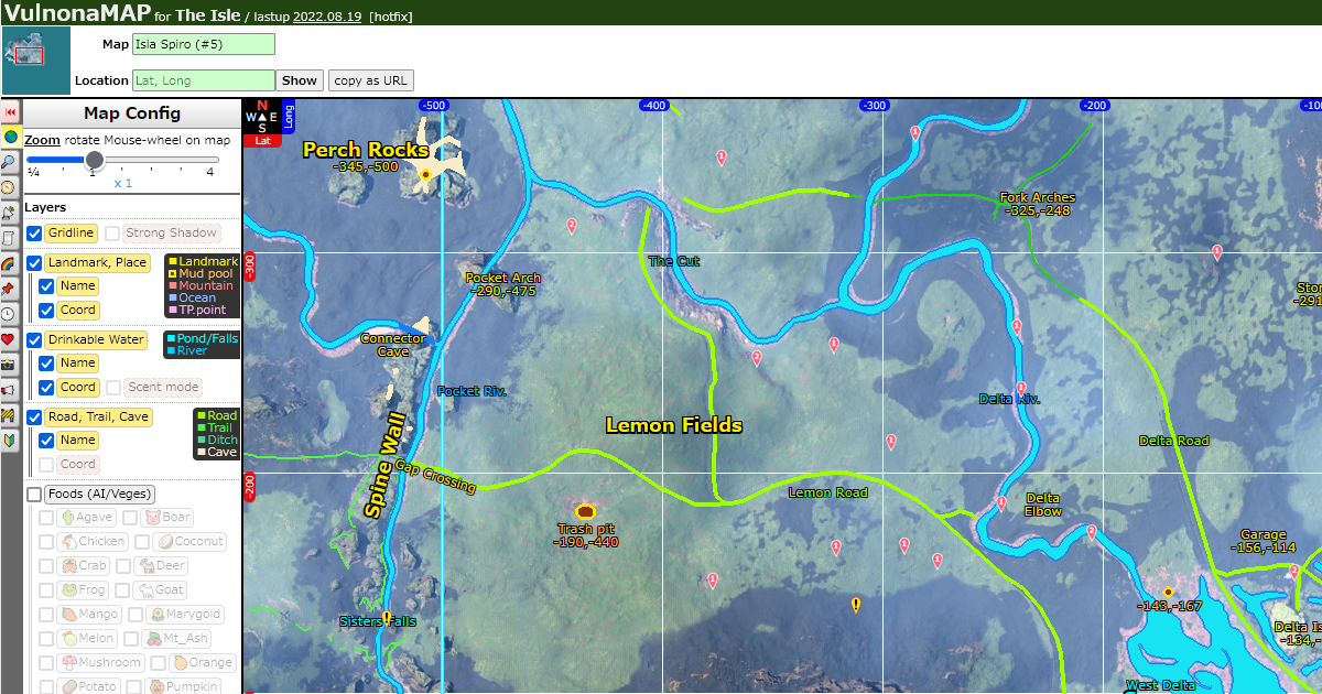
What did you fill in to Location form?
This map allows following 2 format

1, Origin string that copied by click ASSET LOCATION
-------------------------------------------------------------------------------
(Lat: -258,992.266 Long: 49,784.594 Alt: -72,968.141)
-------------------------------------------------------------------------------
* This is able at Legacy only. Not implemented to Evrima yet.
* At some environment, comma and point are swapped or disappeared. But it will be able to use correctly.
Coco.N  [author] Nov 28, 2020 @ 10:06pm 
2, Representation of 1000 units like as "Lat,Long"
* "-123, 456" means (Lat: -123,000.000 Long: 456,000,000)
* This string is consisted:
[1] numeric (If there's a minus sign immediately before, include it)
[2] non-numeric that join those (0 or more length).
[3] numeric (same as [1]).

* Therefore, all of the following are treated as the same coordinates "-123,-456".
----------------------------------------
-123,-456
-123, -456
-123-456
-123 -456
-123.-456
-123aaaaaaaaaaaaaaaaaaaaaaaaaaaaaaaaa-456
----------------------------------------

* However be careful if Long value is 0 or larger, separating character is require 1 or longer length to processed correctly.
----------------------------------------
123,456
123, 456
123 456
123.456
123aaa456 <-- This and aboves are treated as "123,456"
123456 <-- This will be treated as "12345,6"
----------------------------------------
Uhuhuhuhmmm Nov 26, 2020 @ 10:38am 
Well my coordinates isnt displayed like that, they are like 45645 long lat 12438743
3lliot77 Nov 20, 2020 @ 1:16pm 
ive been useing this map for 2 years it the best ive found