Arma 3
346 voti
Halsoy, Norway
71
30
25
24
2
8
   
Premio
Aggiungi ai preferiti
Preferito
Rimuovi dai preferiti
Data Type: Mod
Mod Type: Terrain
Dimensioni del file
Pubblicato in data
185.858 MB
21 giu 2020, ore 12:45
1 nota di rilascio ( visualizza )

Sottoscrivi per scaricare
Halsoy, Norway

Descrizione
The Halsoy terrain is an 8x8 km island based on a Norwegian coastal environment. Proudly created for Viking PMC by Jonmo.

It features a large airfield, Goaldet, a 428 m (1 404 ft) tall mountain, an agricultural landscape, a docking area, and a radar base.

Visit Viking PMC's[vikingpmc.com] official homepage.

We also have a mod discord![discord.gg] If you need to reach me, or have any suggestions / bug reports, they can be made here.

License:
This project is under "Arma Public License No Derivatives (APL-ND)"
More information can be found at:
https://www.bohemia.net/community/licenses/arma-public-license-nd
46 commenti
liwocom 23 ago 2023, ore 19:31 
I hope you can make the whole of Taiwan a Terrain
V3RF0LG3R 16 lug 2023, ore 7:08 
Если так и должно быть, то это странная карта.
V3RF0LG3R 16 lug 2023, ore 7:03 
Какой-то пустой остров, или я чего-то не понимаю. Берега почти полны лесами и поселениями, но ближе к центру острова ничего нет, лишь трава и пару камней.
Darth Sirius 16 mag 2023, ore 13:40 
@StoreTurbo bro aint no way you just said that lmao
NikkoJT 13 nov 2022, ore 8:56 
I really like this map's aesthetic.
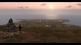
Unfortunately, some of the forest patches on steep hillsides have a lot of floating trees, which is a little jarring.
StoreTurbo 17 set 2022, ore 2:28 
honestly i got scared when i saw norway and a island
МАШИНИСТ 14 ago 2022, ore 1:08 
Большое спасибо за остров!
HORSIE™ 17 nov 2021, ore 14:10 
I love smaller maps, so thank you for this very much @JonMo!
TurboRunk♿ 8 ott 2021, ore 13:52 
Thanks for the Answer, been looking for DATA in Norway above Bergen but never found any evem through QGIS etc.
JonMo  [autore] 8 ott 2021, ore 11:37 
The heightmap was derived a real life 30mx30m accuracy terrain data, followed by editing the data by hand to get it more accurate/detailed and for playability. I've found a new method that allows you to use 1m accuracy terrain data from hoydedata.no and it is definitly the method I prefer now. The original location for the map is Lepsøya just outside Ålesund.